


Tomorrow night Clear 8°C |
Saturday Mostly Sunny 20°C |
Saturday night Partly Cloudy 10°C |
Sunday Partly Cloudy 17°C |
Sunday night Partly Cloudy 8°C |
Monday Cloudy 18°C |
Monday night Showers 12°C |
 |
|
 |
|
METRIC |
IMPERIAL
|
Updated: 19/04/2024 @ 02:35 (0 sec ago) | |||||||||||||||||||||||||||||||||||||||||||||||||||||||||||||||||||
| Temperature | Current Conditions | Forecast / Storm Prediction | ||||||||||||||||||||||||||||||||||||||||||||||||||||||||||||||||||
|
|
|
||||||||||||||||||||||||||||||||||||||||||||||||||||||||||||||||||
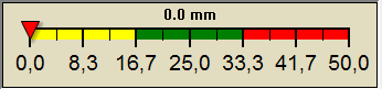
| Dew Point | Liquid Precipitation | Wind Speed | Sun/Moon | |||||||||||||||||||||||||||||||||||||||||||||||||||||||||||||||||
|
|
|
|
|||||||||||||||||||||||||||||||||||||||||||||||||||||||||||||||||
| Humidity | Barometer | |||||||||||||||||||||||||||||||||||||||||||||||||||||||||||||||||||
|
|
|||||||||||||||||||||||||||||||||||||||||||||||||||||||||||||||||||
| Heating Degree Days | Snow3 | Wind Chill | ||||||||||||||||||||||||||||||||||||||||||||||||||||||||||||||||||
|
|
|
||||||||||||||||||||||||||||||||||||||||||||||||||||||||||||||||||
| UV Summary/Forecast | Riassunto Solare | |||||||||||||||||||||||||||||||||||||||||||||||||||||||||||||||||||
|
|
|||||||||||||||||||||||||||||||||||||||||||||||||||||||||||||||||||
| Almanac | Support this Site! | Station All Time Records | Cloud Level | |||||||||||||||||||||||||||||||||||||||||||||||||||||||||||||||||
|
|
|
|
|||||||||||||||||||||||||||||||||||||||||||||||||||||||||||||||||


| 1 Stagione Pioggie: 1° Gennaio - 31 Dicembre. 2 Stagione Neve: 1° Novembre - 31 Marzo. 3 Neve misurata manualmente in tempo reale. |
| WU/TWC Weather Forecast - Outlook Tonight & Tomorrow | ||||||||||||||
|
||||||||||||||
|
||||||||||||||
|
||||||||||||||
|
ajax-dashboard6.php - Version 6.95h - 20-Feb-2023 - Script by: Scott of BurnsvilleWeatherLIVE.com Now supported by Saratoga-weather.org Download |
||||||||||||||